
Finsterwalde
Finsterwalde | |
|---|---|
 Town hall | |
 Coat of arms | |
Location of Finsterwalde within Elbe-Elster district  | |
 Finsterwalde  Finsterwalde | |
| Coordinates: 51°37′42″N 13°42′37″E / 51.628243°N 13.710210°E | |
| Country | Germany |
| State | Brandenburg |
| District | Elbe-Elster |
| Subdivisions | 3 Stadtteile / 2 Ortsteile |
| Government | |
| • Mayor (2017–25) | Jörg Gampe[1] (CDU) |
| Area | |
| • Total | 76.91 km2 (29.70 sq mi) |
| Elevation | 108 m (354 ft) |
| Population (2022-12-31)[2] | |
| • Total | 15,968 |
| • Density | 210/km2 (540/sq mi) |
| Time zone | UTC+01:00 (CET) |
| • Summer (DST) | UTC+02:00 (CEST) |
| Postal codes | 03238 |
| Dialling codes | 03531 |
| Vehicle registration | EE, FI, LIB |
| Website | www.finsterwalde.de |
Finsterwalde (German pronunciation: [fɪnstɐˈvaldə] , Lower Sorbian: Grabin, pronounced [ˈɡrabʲin]) is a town in the Elbe-Elster district (German: Landkreis), in Lower Lusatia, Brandenburg, Germany.
Overview[edit]
It is situated on the Schackebach, a tributary of the Kleine Elster, 28 m. W.S.W of Cottbus by rail. Pop. (2005) 18,840. The town has a Gothic church (1581), a castle, schools, cloth and cigar factories, iron-foundries, flour and saw mills and factories for machine building. Popular are the "four singers from Finsterwalde" and their "singer-song".[citation needed]
History[edit]
Finsterwalde was first mentioned in 1288. Up until the beginning of 17th century, a large part of the city's population was still speaking Lower Sorbian.[3] In 1635, Finsterwalde came into the possession of the Electorate of Saxony and from 1815 it became part of the Kingdom of Prussia.[4] From 1815 to 1947, Finsterwalde was part of the Prussian Province of Brandenburg. From 1952 to 1990, it was part of the Bezirk Cottbus of East Germany.
Demography[edit]
-
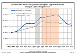 Development of population since 1875 within the current boundaries (Blue line: population; dotted line: Comparison to population development of Brandenburg state; grey background: Time of Nazi rule; red background: Time of communist rule)
 -
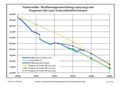 Recent Population Development and Projections: Population Development before Census 2011 (blue line); Recent Population Development according to the Census in Germany in 2011 (blue bordered line); Official projections for 2005-2030 (yellow line); for 2020-2030 (green line); for 2017-2030 (scarlet line)


|
|
|
Known persons[edit]

The following well known persons are from Finsterwalde:
- Hansgeorg Bätcher (1914–2003), Oberstleutnant in the Luftwaffe
- Inge Deutschkron, (1922–2022), German-Israeli journalist and author
- Thomas Eisfeld, (born 1993), football player for Arsenal FC
- Catrin G Grosse (born 1964), artist and painter
- Kurt Haehling (1893–1983), Generalmajor in the Wehrmacht
- Detlef Irrgang, (born 1966), football player
- Sonja Kesselschläger, Heptathlon athlete
- Hermann Kotzschmar, (1829–1908), German-American musician, conductor and composer
- Peggy Kuznik, Football player
- Otto Ostrowski, (1883–1963), Mayor of Finsterwalde in the 1920s
- Stephanie Pohl, (born 1978), beach volleyball player
- Hans-Jürgen Riediger (born 1955), football player
Buildings and Monuments[edit]
- Finsterwalde Solar Park
- Janusz-Korczak-Gymnasium, formerly Knabenschule by Max Taut (1913)
- In Finsterwalde is located a relief dedicated to Lenin in the park "Bürgerheide"[6]
Climate[edit]
| Climate data for Doberlug-Kirchhain [a] (1991–2020) | |||||||||||||
|---|---|---|---|---|---|---|---|---|---|---|---|---|---|
| Month | Jan | Feb | Mar | Apr | May | Jun | Jul | Aug | Sep | Oct | Nov | Dec | Year |
| Mean daily maximum °C (°F) | 3.4 (38.1) |
5.0 (41.0) |
9.2 (48.6) |
15.3 (59.5) |
19.7 (67.5) |
23.1 (73.6) |
25.3 (77.5) |
25.1 (77.2) |
20.1 (68.2) |
14.3 (57.7) |
8.1 (46.6) |
4.4 (39.9) |
14.4 (57.9) |
| Daily mean °C (°F) | 0.6 (33.1) |
1.5 (34.7) |
4.6 (40.3) |
9.5 (49.1) |
13.9 (57.0) |
17.3 (63.1) |
19.4 (66.9) |
19.0 (66.2) |
14.5 (58.1) |
9.6 (49.3) |
4.9 (40.8) |
1.8 (35.2) |
9.7 (49.5) |
| Mean daily minimum °C (°F) | −2.4 (27.7) |
−2.0 (28.4) |
0.3 (32.5) |
3.3 (37.9) |
7.5 (45.5) |
11.0 (51.8) |
13.2 (55.8) |
12.8 (55.0) |
9.2 (48.6) |
5.4 (41.7) |
1.7 (35.1) |
−0.9 (30.4) |
4.9 (40.8) |
| Average precipitation mm (inches) | 45.7 (1.80) |
34.0 (1.34) |
38.8 (1.53) |
27.9 (1.10) |
57.2 (2.25) |
53.4 (2.10) |
69.4 (2.73) |
61.2 (2.41) |
45.8 (1.80) |
39.4 (1.55) |
43.3 (1.70) |
44.1 (1.74) |
561.6 (22.11) |
| Average precipitation days (≥ 0.1 mm) | 17.1 | 13.7 | 15.1 | 11.0 | 13.1 | 12.9 | 14.0 | 12.7 | 11.8 | 13.8 | 15.0 | 16.4 | 166.8 |
| Average relative humidity (%) | 84.5 | 80.6 | 77.0 | 70.5 | 70.5 | 70.0 | 69.0 | 69.9 | 76.6 | 82.3 | 87.1 | 86.2 | 77.8 |
| Mean monthly sunshine hours | 55.2 | 78.0 | 124.7 | 190.8 | 224.2 | 218.7 | 228.4 | 220.4 | 163.7 | 114.1 | 62.2 | 48.3 | 1,741.3 |
| Source: NOAA[7] | |||||||||||||
Notes[edit]
- ^ Doberlug-Kirchhain is located approximately 10 kilometres (6.2 mi) west of Finsterwalde.
References[edit]
- ^ Landkreis Elbe-Elster Wahl der Bürgermeisterin / des Bürgermeisters, retrieved 1 July 2021.
- ^ "Bevölkerungsentwicklung und Bevölkerungsstandim Land Brandenburg Dezember 2022" (PDF). Amt für Statistik Berlin-Brandenburg (in German). June 2023.
- ^ Der Niedersorben Wendisch. Eine Sprach-Zeit-Reise. Bautzen 2003, p. 69
- ^ One or more of the preceding sentences incorporates text from a publication now in the public domain: Chisholm, Hugh, ed. (1911). "Finsterwalde". Encyclopædia Britannica. Vol. 10 (11th ed.). Cambridge University Press. p. 393.
- ^ Detailed data sources are to be found in the Wikimedia Commons.Population Projection Brandenburg at Wikimedia Commons
- ^ https://leninisstillaround.com/2015/07/20/in-front-of-the-playground/ checked 26.1.2020
- ^ "Doberlug-Kirchhain Climate Normals 1991–2020". National Oceanic and Atmospheric Administration. Archived from the original on 16 September 2023. Retrieved 16 September 2023.
External links[edit]
![]() Media related to Finsterwalde at Wikimedia Commons
Media related to Finsterwalde at Wikimedia Commons
Towns and municipalities in Elbe-Elster | ||
|---|---|---|
|  | |
| International | |
|---|---|
| National | |
| Geographic | |
This Brandenburg location article is a stub. You can help Wikipedia by expanding it. |